Recreating Bethel Avenue
The Recreating Bethel Avenue Initiative relates to the MAP Initiative 4, Creating Attractive and Desirable Places, by creating a safer more pedestrian friendly street. This initiative also creates a better connection between the Anthony Neighborhood and Ball State University with less vehicle-pedestrian conflict. It relates specifically to Initiative 4, Creating Attractive and Desirable Places by creating a more desirable and safe street for pedestrians and vehicles while improving aesthetics
Why this is important
During the Anthony Neighborhood Association meeting, Bethel Avenue was a topic that was brought to attention. Most residents agree that crossing is a safety hazard for pedestrians.
This is important to the neighborhood. Many Residents of the Anthony Neighborhood are undergraduate students who attend Ball State University. The only thing separating Anthony and Ball State is Bethel Avenue. However, Bethel is a 4-lane road with little to no areas for crossing. The width of Bethel Avenue presents a huge risk to the safety of students trying to cross. Along with the hazardous crossing conditions, the 5-way intersection at Bethel and New York cause both confusion and congestion. The Anthony neighborhood could benefit extremely from the improvement of Bethel Avenue.

What this will involve
To complete this task there will be some infrastructure improvements such as a road diet and the creation of a roundabout. The Muncie Street Department or the local municipal planning department can help with these improvements. The neighborhood could raise awareness, notify the city, and oversee the project.
TIFs (Tax Incremented Financing) is an option that many cities and municipalities use when implementing large infrastructure projects. It is a public financing method that is used as a subsidy for redevelopment, infrastructure, and other community-improvement projects. Since its campus borders Bethel Avenue, Ball State may also be interested in financially supporting the project.
Contact information for ASSISTANCE sources
Muncie Street Department
5790 W Kilgore Ave, Muncie, IN 47304
Phone: (765) 747-4847
Department of Community Development
300 N. High St. City Hall
Muncie, IN 47305-1639
Phone: (765) 747-4825
Fax: (765) 747-4898
Contact: Hugh S. Smith, Principal Planner
Email: cgregory@cityofmuncie.com
Email: hsmith@delawarecounty.in.us
http://www.hud.gov/local/in/community/cdbg/
http://www.co.delaware.in.us/department/?fDD=20-0
Priority analysis
A map showing existing street conditions as well as street sections. The street sections, along with section cuts, will show what the new proposed street design will look like. There will also be a map that highlights areas that are in most need of improvement. This will help give priority help to areas in need.

Case studies
Miami University Crosswalk
Like Ball State, Miami University also had issues with busy roads along the edge of its campus. The elimination of a marked crosswalk from the southeast side of Shriver Center did not stop students and others from crossing that busy stretch of road.
This year about 2,800 daily crossings occurred – illegally – at that spot despite no crosswalk designation. “Students were seen stopping in the middle of the street waiting for cars to stop in order to walk across,” said John Seibert, Miami’s director of planning, architecture, and engineering.
With results from a transportation study, Miami’s physical facilities department took ideas to the campus planning committee, the city, and parking-transportation committees to improve the safety of pedestrians at that location.
The result is a soon-to-be-built crossing with a pedestrian island. The island is the width of the center traffic lane. It has lights that flash when someone is preparing to enter the intersection. This will eliminate what is currently a left-turn lane for southbound cars.(Source)

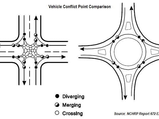
Carmel Roundabouts
Carmel, IN has 105 roundabouts within its 47 square miles. According to the mayor’s office, the community plans to add at least 30 more roundabouts. When construction is completed on all of Carmel’s proposed roundabouts, there will be one loop for every 650 Carmel residents.
The angle and speed of traffic of roundabouts led to swift declines in accidents. In geometric terms, roundabouts simply have fewer “conflict points.” Where a traditional two-way intersection has 32 places for cars to collide, a modern roundabout only has eight points of conflict. This can be seen in the image below. Because cars in a roundabout are moving in one direction, instead of squaring off at an intersection, head-on collisions are all but eliminated. (Source)